Askeri Arkeoloji: Poisk.Pro Arpad Hattındaki Gizli Tünelleri Keşfetti
Dedektör
OKM Rover C II New Edition (2009-2017)
Derinlik: 20.0 m (65.6 ft)
Bölge: Zakarpattya
Başlangıç zamanı: 1939
Tarafından keşfedildi Poisk.Pro
Dünya Savaşı sırasında en etkili tahkimat sistemlerinden biri olan Arpad Hattı ve sığınak kompleksi, Rus ordusunun sayısal üstünlüğüne rağmen taarruzlara dayanmıştır. Sovyet birlikleri hattı aşıp Romanya'yı işgal ettikten sonra Macar kuvvetleri nihayet geri çekildi.
Yarım asırdan fazla bir süre sonra, Ukrayna'dan uzman ekip Poisk.Pro, yeraltında hala nelerin saklı olduğunu ortaya çıkarmak ve tesislerde geride bırakılanları yeniden keşfetmek için bölgeyi ve sığınak kompleksini araştırdı.
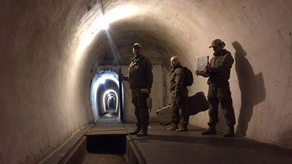
Yeraltı Tünel Sisteminin Yeniden Keşfi
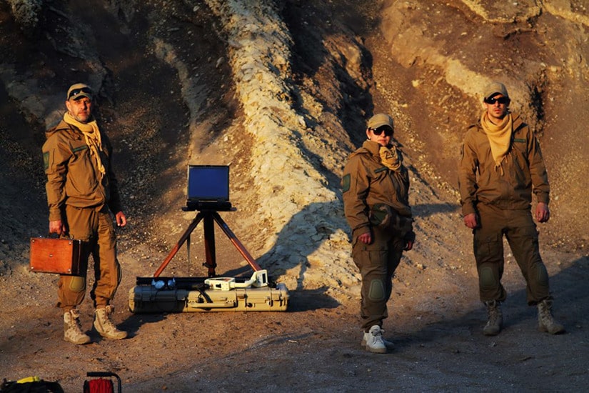
OKM Rover CII New Edition ile donatılan Poisk.Pro araştırma ekibi, Zakarpattya bölgesindeki Arpad Hattı'nda bulunan bir sığınak kompleksini inceledi. Yer tarayıcısı, tesisin güney tarafında yaklaşık 20 metre derinlikte bir yeraltı geçidi tespit etti.
Sadece turistlere kısmen açık olan tünel sisteminin içinde değil, aynı zamanda tepelerde de jeoradar ve yer tarayıcıları başka gizli tüneller ve yeraltı sığınak kompleksine girişler tespit etti. Şaftları ağır metal kapaklarla kapatılmıştır. Ana girişi batı tarafında yer almaktadır.

İki seviyesinden ilki yaklaşık 20 ila 30 metre derinlikte yer almaktadır. Tüneli takip ettiğinizde, yaklaşık 25 metre sonra nizamiyeye ulaşırsınız, 20 metre sonra başka bir kapakla reviri bulursunuz. Revirden 150 metrelik bir koridor ve 84 basamakla ikinci kata çıkılır. Yüzeye çıkan iki çıkış yeraltı mezarlarını daimi yangın mevzilerine bağlamaktadır. Alt kat, Podpolozie köyü yönünde bir tünele erişim sağlamaktadır.
Daha fazlasını poisk-pro.com adresinde okuyun

Tarihsel Arka Plan: İkinci Dünya Savaşı'nda Sığınak Sistemi
Arpad Hattı, kuzeydoğu Karpat Dağları'nda bulunan ana savunma hattıydı. Sığınakları ve tünelleri, eski Macaristan Krallığı'nın sınırlarını Rusya'dan korumak için 1939 ve 1944 yılları arasında inşa edilen bir savunma sistemi.
Dağlık alan etkili bir savunma potansiyeli sunuyordu: Ordu, sığınak konumundan Lviv-Budapeşte-Viyana otoyolu boyunca her türlü hareketi kontrol edebiliyordu. Dahası, maliyet oranına göre etkinlik açısından Arpad Hattı, İkinci Dünya Savaşı sırasında en etkili tahkimat sistemlerinden biriydi: daha ucuz inşaat, daha uzun süre direniş ve düşmanın sayısal üstünlüğüne rağmen son derece düşük kayıplar.
Nihayet 1944'ün sonunda, Sovyetlerin Romanya'yı işgali ve Transilvanya'yı kaybetmesinin ardından Macar kuvvetleri geri çekildi. Sovyet birlikleri Tuna Nehri boyunca ilerleyerek hattı aştı.
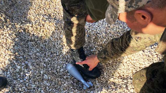
Yeraltı tünel sistemi, Rus Geçidi boyunca Uzhgorodsky, Mukachevo ve Yasinyansky gibi kale ve tahkimatları birbirine bağlamaktadır. Kompleks ayrıca sığınaklar, askerlerin barınması için barakalar, kalıcı ateş mevzileri, mazgal ve tanksavar bariyerleri, siperler ve duvarlardan oluşuyordu. Raporlara göre, gizli tünellerde hala silah, mühimmat ve gıda maddeleri bulunmaktadır.
Sığınak Kompleksinin Kaşifleri
Poisk.Pro, Ukrayna'da ve yurtdışında 40 metreye kadar derinliklerde gizli nesneleri ve yapıları arayan arkeoloji araştırmacıları ve jeofizikçilerden oluşan profesyonel bir ekiptir. Ayrıca, Poisk.Pro arkeolojik kazılar düzenler ve yürütür, yeraltı iletişimini ve teşhisini izler ve jeoteknik mühendislerini destekler.
Aradığınızı biz buluruz!

Ekip, çeşitli kullanım durumları için verimli zemin ölçümleri için gerekli olan jeoradar, zemin tarayıcıları ve diğer cihazlarla profesyonel olarak donatılmıştır.
- Arkeolojik kazıların ve maden aramalarının organize edilmesi ve yürütülmesinde yardım, profesyonel GPR araştırması.
- Çeşitli toprak türlerinde ve su altında demir ve değerli metal alaşımlarının tespiti.
- Doğal ve yapay kaynaklı boşlukların tanımlanması ve binaların duvarlarının ve temellerinin incelenmesi.
- İnşaat halindeki bölgelerde toprak stabilite durumunun teşhisi ve mühendislik yapılarının izlenmesi.
- Jeofizik ekipmanlar, jeoradar ve tarayıcılar ile çalışma konusunda eğitim ve profesyonel danışmanlık.
Poisk.Pro
38 (097) 876 39 00
geopoisk.pro@gmail.com
Verimli Keşifler için Profesyonel Taktikler
Keşif Çalışmasının Hazırlanması
Doğru ve anlamlı ölçüm sonuçları elde etmek için ilk adım alanın jeofizik araştırmalara hazırlanmasıdır. İlk olarak, tutarlı bir ölçümü engelleyebilecek çalılar, dallar ve ağaç gövdeleri gibi engeller tarama alanından kaldırılır. Daha sonra manyetometre, tarama alanını ilgi çekici olmayan metal nesnelerden temizlemek için kullanılır.
Elektromanyetik alanlarıyla yüksek voltajlı elektrik hatları ölçümleri yanıltabileceğinden, yakın çevrede metal dedektörleri ve yer tarayıcılarının kullanılması önerilmez. Zemine yapılan müdahalelerden ve kazılardan sonra da tarama yapmak zordur, çünkü bu önlemler dünyanın doğal manyetik alanını bozar ve tarayıcı artık istenen nesnelerin yerini tespit edemez.

Poisk.Pro ekibi, tüm araştırma projelerinin yalnızca yürürlükteki mevzuata uygun olarak yürütülmesini sağlar.
Zemin Ölçümlerinin Değerlendirilmesi
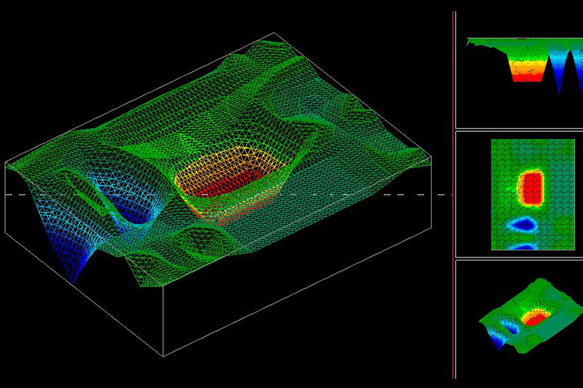
OKM dedektörleri ile yapılan zemin taramaları Visualizer 3D yazılımı ile değerlendirilebilir. Ölçülen değerler farklı renklerde görüntülenerek, metal kutu veya boru hatları (kırmızı renkte görselleştirilmiştir) gibi ferromanyetik sinyaller net bir şekilde tanımlanabilir. Tüneller, yeraltı odaları ve kuyular (mavi ile gösterilmiştir) gibi boşluklar da tespit edilebilir. Görselleştirmeler, tespit edilen yapıların konumunu, boyutunu ve derinliğini belirlemeye olanak tanır.

Profesyonel Araştırma ve Keşif için Çok Yönlü Ekipman
Poisk.Pro, ister karada ister su altında olsun, her türlü görev için zemin ölçüm cihazları, sondaj ekipmanları, endoskop kamera, profesyonel navigasyon araçları, tırmanma ekipmanları ve bir şişme bot ile donatılmıştır. Bu ve diğer ekipmanlarla uzman ekip, Ukrayna'da ve yurtdışında profesyonel araştırma ve keşif için hazırdır.


Diğer Arama Projeleri ve Keşifler
Poisk.Pro'nun odak noktası, Üçüncü Reich hazinelerini ve Dünya Savaşlarından yağmalanan değerli eşyaları bulmak amacıyla askeri arkeolojidir.
Bunlara ek olarak, diğer heyecan verici arama projeleri arasında bir Katolik kilisesinde yapılan keşifler de yer almaktadır: Georadar, yeraltı mezar alanlarını ve boşluklarını bulmak ve ortaya çıkarmak için kullanıldı.


Get Rewarded for Your Treasure Finds
You have also made discoveries and detected amazing artifacts and would like to share them (anonymously)? We look forward to reading and publishing your success stories!
Kumdan havan topuna: Frank Casser Tunus ordusunu yere nüfuz eden radar kullanımı konusunda eğitiyor
Frank Casser, Tunus ordusunu Yer Radarı (GPR) konusunda eğitiyor ve mühendisler ile uzmanlara havan topları ve yeraltı tehditlerinin nasıl tespit ...

EULEAD Libya'da Toplu Mezar Araştırması için OKM Georadar Sağlıyor
EULEAD projesi aracılığıyla Avrupa Birliği, Libya'daki Tarhouna Toplu Mezarları ile ilgili çalışmalarında CID Kriminal Soruşturma ekibini destekliyor. EULEAD'in desteği sayesinde ...

Sechura Çölü'nde (Peru) Yer Tarayıcısı Rover C II ile tespit edilen Gümüş Sikkeler
Çok amaçlı 3D metal dedektörü OKM Rover C II ile Peru'daki Sechura Çölü'nde bulunan madeni para hazinesi gibi farklı arazi ...